Gegharkunik marz is situated in the eastern part of Armenia. Its center is Gavar town, one of the main industrial centers of the country. It is situated on the slopes of the Geghama mountains. Lake Sevan is situated in the center of the marz. The name of the lake dates back to Urartian times (Siuna – country of lakes). In ancient times the lake was called Geghama Sea. Sevan is one of the largest high-altitude fresh water lakes in the world (area – 4890 sq.m., altitude – 1900 m). There are numerous hotels, motels and vacation retreats on the banks of the lake.
The marz is rich in historical monuments. The objects dating back to 3rd-2nd millennium B.C. were found during archeological excavations in the ancient settlement Lchashen.
You can hardly imagine Sevan without Sevan monastery, built on the peninsula in 784. From the left of the major road leading to Gavar town, there’s Ayrivank church (9th-10th centuries), a wonderful example of a piece of architecture that perfectly matches the landscape. In the North East Noraduz is situated, which is known for its collection of khachkars from the 5th to the 20th centuries. The lands of Mastrik are known for its gold mines, which have been developed from centuries past and works of Armenian jewelers are still renowned.
Lake Sevan originated due to volcanic activity in the Quaternary formation of our planet. Eruption of lava on the northern slopes of the Geghama range flooded the valley of the ancient river. The resulting bolson was filled with melt water from glaciers and snowfields surrounding the ridges and later with river water. Ancient reserves of water sought the way out and found it by cutting through the shaft of the dam. That’s how the flow to the Razdan river valley began.
The 8-kilometer strait between Noraduz and Artanish capes connects the pools of Big and Small Sevans. The lake’s surface area is 972 sq.m. with the maximum depth of 99 meters. Water surface lies at the altitude of 1,897 meters above sea level, water reserves amount to 34.2 cubic meters. Sevan is fed up by 28 rivers and only one flows out – the Razdan river, which connects the lake with Arax and Kura. Both the lake and rivers flowing into it are fed up by rain and melted snow.
It’s hard to describe the beauty of Sevan, you need to see this lake. When traveling to Armenia, one of the major goals for many tourists is to enjoy Sevan, see the sunrise over the tops of the Sevan mountain range, observe all the shades of turquoise water and listen to the screams of gulls among mountain ranges, observe the colonies of pink flamingos and pelicans and breathe pure air of high mountains.
The life of Lake Sevan was almost ceased by civilization that tends to create dozens more serious new problems by solving one problem in its fight against nature. In the 30s it was decided to use centuries-old water reserves within 50 years for irrigation and hydropower needs, by completely draining Big Sevan. In the cup of Small Sevan it was supposed to leave a small lake of 239 sq. km. Sevan draining was started in 1938 (see Ecology of Lake Sevan).
Time clarifies the errors, but cannot always fix them. People realized that waters of Lake Sevan equally belong to future generations. However, by that time the lake level was dropped by more than 18.5 meters, its area decreased by more than 13%. There were also changes in composition of water and oxygen regime of the lake. Water transparency decreased by three times, it began to bloom with blue and green algae. Many aboriginal fish species of Lake Sevan have gone forever. The bare bottom in most cases was destroyed by erosion The island in the north-west that used to raise its steep rocky shores at 64 meters above the surface of the lake, has become a peninsula connected with the mainland by the outstanding sand ridge.
To stop the drop in lake level completely without using irrigation and hydropower was only possible with the help of flowing extra amounts of water. In 1981 they began to replenish Sevan with waters of the Arpa and Yehegis. For this there was built a tunnel from the Arpa river and water storage basin set not far from Jemruk to Lake Sevan. The tunnel route passes under the mountain range between the Arpa and Yehegis and under the Vardenis range. The total length of the tunnel is 48 kilometers and 420 meters with a maximum depth of its inception of 1230 meters. The tunnel is connected with the lake by the open channel with the length of 850 meters.
Cafe and restaurant
|
Artificial Stone Factory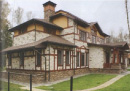
|
Travel Agency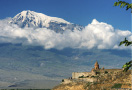
|
Armenian Heritage
|


